Managing Avalanche Risk Part 4: Using Public Avalanche Forecasts
In this fireside chat series on managing avalanche risk, Karl Klassen will pass along the wisdom acquired from his mentors and the knowledge learned from a distinguished career as avalanche forecaster and backcountry ski guide—to help you better understand avalanche hazard and how to manage the inherent risk you face.
My least favorite task as warning service manager at Avalanche Canada is accident analysis. When serious incidents occur, my job is to audit our forecasts for accuracy and effectiveness. While they aren’t always 100 percent perfect, I can say with confidence that public forecasts offer the information and guidance needed to prevent most accidents. I believe public avalanche forecasts are the best hazard assessment tool for most recreationists most of the time. And, while they can be intimidating and complex, with a little guidance and effort anyone can use a forecast effectively.
In this article I’ll go over the fundamental parts of a forecast that everyone, from novice to veteran needs to understand. Then I’ll outline a few simple scenarios to illustrate how to assess hazard and integrate it into a basic risk management strategy. But, before we get to that…
Reading this article, or even this whole series isn’t enough. You and everyone in your group needs training. Going into the backcountry with no training is like buying a boat and setting off to sail to Hawaii when all you know is how to swim. In theory, I guess you might survive if all the stars line up, but chances are you’ll not make it. And even if you are trained and your crew is not, you’ll likely die if you go overboard.
To use an avalanche forecast effectively and manage risk, you have to be competent in recognizing terrain. And you need to be able to identify slope aspect and elevation in the field. These are fundamental skills, and you can’t be safe without them.
You’d be surprised how many times people involved in accidents didn’t read the forecast , or “just skimmed it.” You can’t assess hazard or manage risk if you don’t use the information available or just pay it lip service. Please read the forecast carefully and completely before you go out. Better yet, read the forecast for several days leading up to and on your departure date. If you live in the mountains and go out regularly, reading the forecast should be part of your daily routine. Ideally, make it a team effort and work together on interpreting and using the forecast in your risk- management process.
You can’t follow through on your risk- management plan if you can’t remember the forecast and risk- management strategy. Write these down or save them to your phone. Take them with you and refer to them at decision points.
Okay, let’s get into the forecast. First, the danger ratings.
Yes, yes, I know. You’re a high-end user and don’t think danger ratings apply to you—you’ll just read the technical details and work it out as you go. I think you’re wrong. The ratings synthesize all the data and analysis that went into the forecast. You should start here no matter how smart, well trained, or experienced you are.
Green/low: Unless you see signs to the contrary, avalanches are unlikely. Any avalanches that might occur are probably not going to be deadly.
Moderate/yellow: Avalanche hazards exist that could injure or maybe even kill you if you don’t do a bit more work to figure out what you’re dealing with.
Considerable/orange: This rating probably doesn’t scare you nearly as much as it should. Novices need support and mentorship. You need to delve much more deeply into the forecast and create a detailed risk management strategy. Ongoing field validation and reassessment of hazard and risk is essential. If you don’t fully understand the issues or can’t clearly define where or when you’re at risk, stay out of avalanche terrain.
High/red: Large, un-survivable avalanches are expected. You really need to know what you’re doing if you plan to go out in these conditions. Novices should not expose themselves to avalanche terrain unless they are with a known and trusted mentor capable of creating and implementing a hazard assessment and risk management plan that’s more detailed than the simple process outlined in this article.
Extreme/black: Widespread, deadly avalanches that will almost certainly run a long way are as certain as you can be in this business. This is a good day for resort skiing or cross-country skiing on groomed tracks. If you do go into the backcountry, avoid avalanche terrain like the plague.
You’ve decided to go out? Okay, but look at the avalanche problems before you go.
Avalanche problems can be intimidating, especially if you’re new to the game. But here’s the thing. At the basic level, what you really need to know is the location of the problem (usually expressed as elevation and aspect) and the destructive size rating.
However, just looking at danger ratings and avalanche problems isn’t enough. Now it’s time to put the picture together and come up with a risk management strategy. The following three scenarios walk you through it.
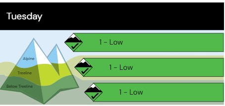
Scenario 1:
- Danger ratings:
- Alpine: Low
- Treeline: low
- Below treeline: low
- Avalanche problem:
- No avalanche problems listed.
- Hazard assessment:
- No significant avalanche hazard expected.
- Risk-management strategy:
- Look for signs of avalanche hazard (more on this in future articles). Back off and reassess if you see them.
- Use standard safety protocols in avalanche terrain.
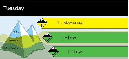
Scenario 2:
- Danger ratings:
- Alpine: moderate
- Treeline: low
- Below treeline: low
Avalanche problem No. 1:
Elevation: alpine
Aspects: N, NE, E
- Size: 1 to 2/small to large
- Hazard assessment:
- Avalanches large enough injure or bury a person expected in the alpine on north, northeast, and east aspects.
- Risk-management strategy:
- Avoid avalanche terrain on north, northeast, and east aspects in the alpine.
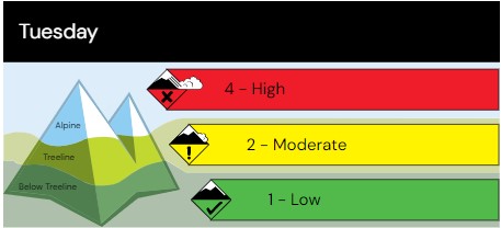
Scenario 3:
- Danger ratings:
- Alpine: high
- Treeline: moderate
- Below treeline: low
- Avalanche problem No. 1:
- Elevation: alpine
- Aspects: N, NE, E
- Size: 3 to 4/very large
- Avalanche problem No. 2:
- Elevation: treeline
- Aspects: SE, S
- Size: 2/large
- Hazard assessment:
- Avalanches large enough to destroy a railway car or 4 hectares/10 acres of forest are expected in the alpine on north, northeast, and east aspects. Avalanches this big could run quite far, possibly right to valley bottom on large slopes.
- Avalanches large enough to bury or injure a person expected at treeline on southeast and south aspects.
- Risk-management strategy:
- Avoid avalanche terrain on north, northeast, and east aspects in the alpine.
- Avoid avalanche tracks and runouts below alpine start zones on north, northeast, and east aspects at treeline and below treeline.
- Avoid all avalanche terrain on southeast and south aspects at treeline.
I’m not suggesting a regional public forecast alone and a basic risk management strategy will keep you 100 percent safe. It’s definitely not always as simple or obvious as the scenarios above. We’ll build on this basic approach in future articles.
But I’ll be blunt: if everyone did nothing more than what I just outlined in the scenarios above before they left, wrote down their hazard assessment/risk management strategy and followed through in the field, the number of injuries and fatalities due to avalanche involvements would go down significantly.
Karl Klassen is an internationally certified mountain guide known for developing the avalanche curriculum with Avalanche Canada. He is also the public avalanche warning service manager at Avalanche Canada.