New Tech from onX Maps May Save Your Life
Photo of Hoosier Pass avalanche courtesy of Colorado Avalanche Information Center.
On Jan. 8, 2022, Hannah Nash, 25, and Drake Oversen, 35, and their dog, Valerie, of Colorado Springs, Colo., went missing after heading out on a casual snowshoe to Crystal Lake, a popular winter and summer destination on Hoosier Pass. They carried no avalanche gear—beacon, shovel, probe—and had no intention of walking through avalanche terrain.
After friends reported them missing that evening, Summit County Rescue Group, Summit County Sheriff’s Office, Flight for Life, and the Colorado Rapid Avalanche Deployment program eventually located them with the help of avalanche dogs. Both Nash and Oversen, as well as Valerie, had perished in an avalanche that they triggered on a steep slope just above the road they had been following.
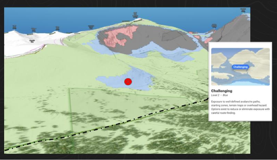
This tragedy is one of many that digital mapping company onX Maps hopes to help backcountry users avoid with a new layer they’re integrating into their platform. The layer incorporates ratings known as the Avalanche Terrain Exposure Scale (ATES), visible in color shadings, so users can instantly see what terrain is most likely to slide, where an avalanche is most likely to propagate, and how far the runout is likely to extend. If Nash and Oversen had this technology at their fingertips before planning their route to Crystal Lake, they could have easily avoided the slide that took their lives.
ATES itself isn’t new—it was created by Parks Canada in 2003 after a natural avalanche crossed a valley floor in Glacier National Park on Rogers Pass, B.C., and killed seven children who were on a class field trip to the area. The scale’s principal architects—Grant Statham, Ian Tomm, and Bruce McMahon—designed it in response to the tragedy to better communicate to the public what terrain is in the path of avalanches.
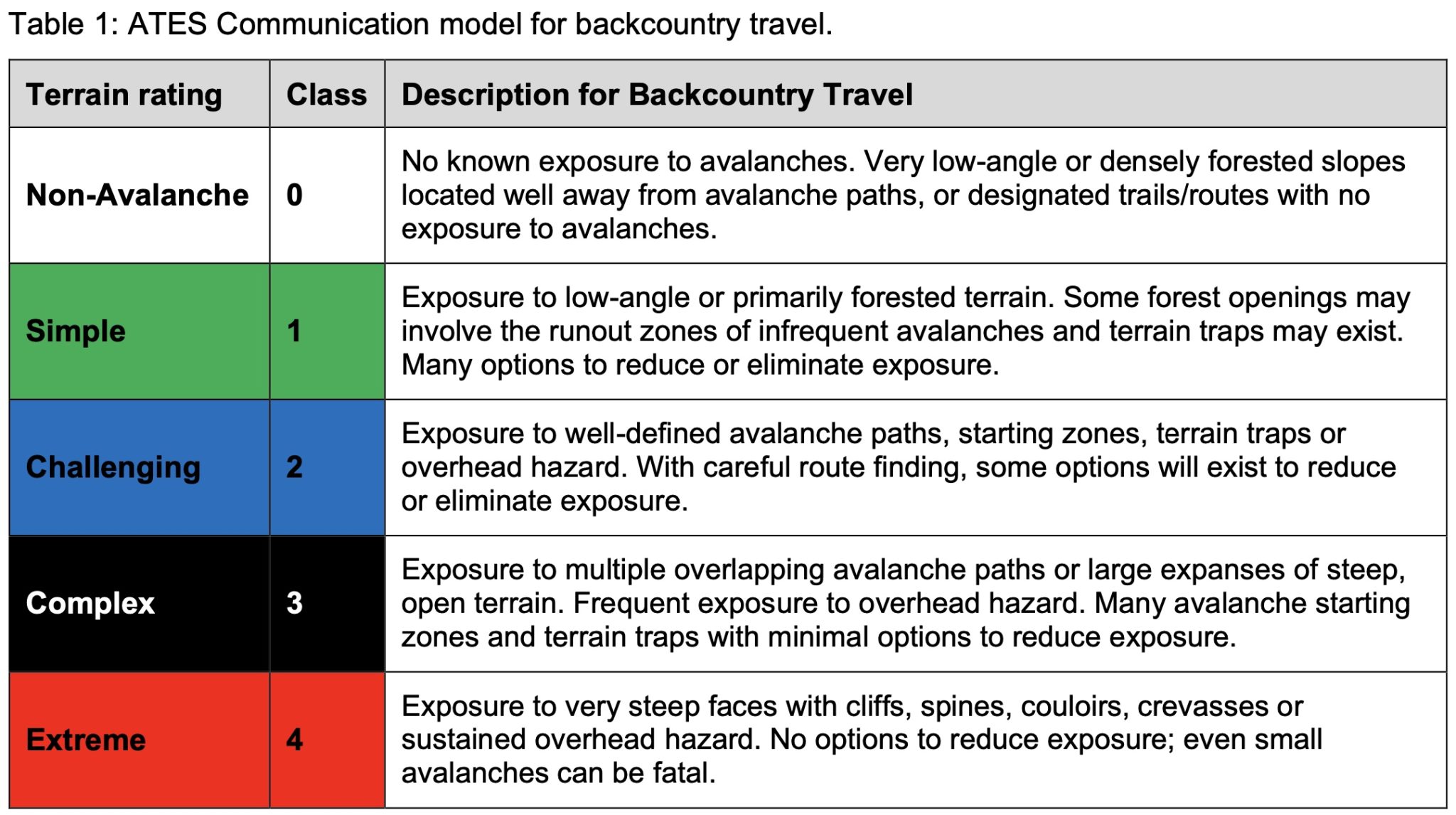
Unlike the North American danger rating scale developed in the 1990s that uses analysis of the snowpack and weather to assign a low, moderate, considerable, high, and extreme danger rating to slopes according to their elevation, the ATES scale only evaluates the terrain itself. ATES does not take the snowpack or current forecast into consideration; in the dynamic backcountry environment where conditions are constantly changing, the ATES rating is the sole static metric. It answers what is perhaps the most important question of all when traveling in the backcountry: “Am I in avalanche terrain?”
“There are three main ingredients to an avalanche: weather, snowpack, and terrain,” said Charlie Von Avis, senior product manager of onX. “ATES gives us a standard definition of terrain.”
ATES has five color-coded designations—non-avalanche, simple, challenging, complex, and extreme—which ramp up from relatively safe to potentially extremely dangerous. Users can then use this knowledge in conjunction with the snowpack and weather to make more informed decisions.
Click to Enlarge
“ATES gives you five controls you need, not 20,” said Andy Sovick, founder of Beacon Guidebooks, who has been working with onX to incorporate both his guidebook content and the ATES scale into the app. (Sovick has been publishing ski lines with locally evaluated ATES ratings for years.) “We’re baking the cake for you—layering and simplifying things for the user—versus them trying to bake the cake themselves.”
According to Billy Rankin, avalanche educator and ski guide for Irwin Guides in Crested Butte, Colo., the ATES layer will be a powerful tool for backcountry users to be able to instantly see where not to go on any given day. “This makes it so much more black and white when you’re tour-planning with people. Terrain is everything. Assessing the weather—good luck. Snowpack is uncertain. And humans are uncertain trying to make decisions together at the top of the slope. But terrain has the least amount of uncertainty. We can put our hat on it: Terrain’s terrain. It’s always the same, and you really have to rely on it.”
This tool has the capability to help all backcountry users manage risk, but it may have the single greatest advantage to the least experienced—people like the snowshoers who died that day on Hoosier Pass. Seasoned backcountry skiers typically enter avalanche terrain because, well, they like to skis slopes greater than 30 degrees. And these folks will still have to weigh the ATES rating against the snowpack and weather and make their own decisions to go or not go. But for those who have zero desire to enter avalanche terrain, the feature will show them instantly where their tour path should lie. The problem therein might be in how to get the least experienced users—who typically do not use mapping software—educated about the technology. To that end, onX hopes to reach some of these folks by giving free subscriptions to new students enrolled in AIRE level 1 classes.
ATES has been around since the early 2000s, yet onX is the first to incorporate it into digital maps. Until recently, the ratings were limited mostly to manually generated maps and guidebooks like Sovick’s because they were labor- and cost-intensive to assign, making it impossible for platforms like onX to feasibly tackle the project. But in 2020, a grad student by the name of John Sykes developed a program called autoATES, which uses geospatial models to calculate ATES ratings across all digitally mapped terrain.
“No one would be able to figure out if he were hit by a bus,” joked Sovick. “In doing 16 guidebooks, I spent 250 hours rating ATES. And that represents 2 percent of the ski terrain in North America. By myself, I’m never going to get it done. Working with autoATES is so satisfying because I know it’s going to be a lifesaving tool.”
AutoATES starts with satellite-generated beta of slope angle and forest canopy cover, which provides historical records of where avalanches have occurred. That information then allows the program to predict potential release areas and—when crunched with complex calculations involving alpha angles, mass, density, and speed—simulate runouts. It then shows the terrain shaded with the color that corresponds to its ATES rating.
In comparison with ATES maps that were generated manually, autoATES ranks about the same in terms of accuracy, roughly 83 percent. In a concerted and laudable effort to increase accuracy, onX is fact-checking the autoATES ratings, which are public and available for any mapping company to use, with human experts—avalanche forecasters and ski guides—in each area.
“If GAIA wanted to use it, they could do it tomorrow. But the human part is unique to onX,” Sovick said. But, added Joe Risi, senior public relations, events, and partnerships manager at onX, “It’s highly doubtful that other companies are going to do the due diligence of having humans and forecasters to go through the autoATES.”
The legwork required for the human part of the equation is time consuming, to say the least, and onX is rolling out the most popular zones one at a time. To date, the areas where the ATES layer available to users are many parts of Colorado (Crested Butte, Silverton, Loveland Pass) and zones around Salt Lake City and southwest Montana.
“It must be hard for a tech company to say, ‘Slow down and let’s let these ski bums in mountain towns weigh in,’” said Sovick. “But it’s pretty cool that onX is.”
Support The Powder Cloud
The Powder Cloud is dedicated to providing you the education and mentorship required to travel safely and find the happiness in the backcountry.
We’d like to ask for your support—for our scrappy editorial team, our wise and experienced contributors and to help us develop new and creative ways to educate all backcountry skiers and riders.
If you are able, please consider supporting us. Thank you and we appreciate you.
Related Posts
Loading...