Terrain Tip No. 3: Steep Enough to Slide
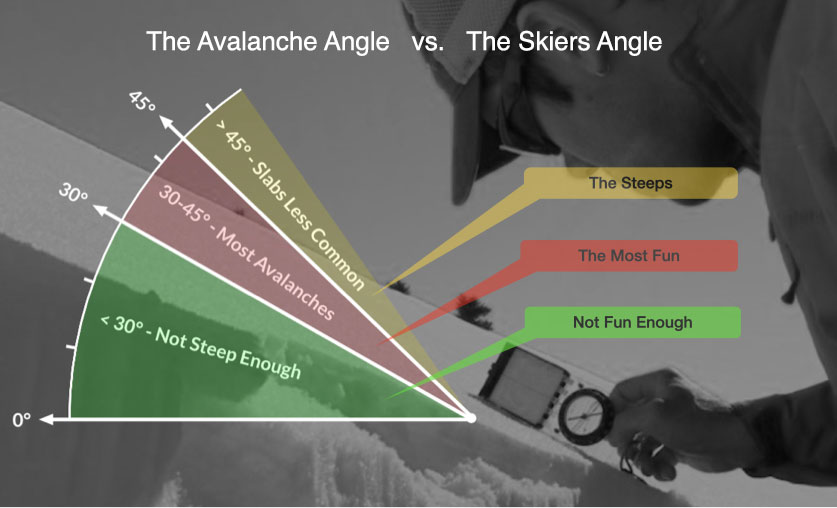
Every avalanche course teaches that the primary terrain feature of an avalanche start zone is the incline of the slope (a.k.a. slope angle). And that most skier-triggered slab avalanches occur on slopes between 30 and 45 degrees. In dry alpine snow, slopes under 30 degrees release only when very unstable. Slopes over 45 degrees frequently sluff during a storm but are less likely to result in a larger, more destructive slab avalanches. So how do we avoid avalanches? Avoid slopes steeper than 30 degrees—right? I think most avalanche rescue teams would confirm that doing so is not that easy, nor that popular.
Tip: Desire can distort our perception of the seriousness of terrain
The first problem to conquer is our own desire. When conditions are good, backcountry skiing is fun at any slope angle. On the downhill ride, however, we’ve all felt that thrill increase as the slope steepens. Then we want more. Our desire to ride a steeper line will naturally distort our ability to assess that downhill slope for what it is—an avalanche path.
Tip: Our eyes tend to average slope angle instead of focus on the incline of the steepest most critical section of terrain
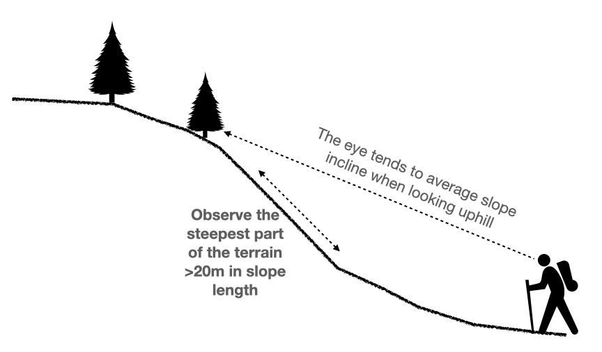
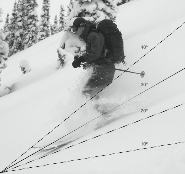
Your eyes tend to average slope angle. For example, when looking upslope, even with a measuring device such as an inclinometer, our brains average the slope angle between our position and the top of the slope, rather than targeting the steepest feature within that terrain. Jürg Schweitzer, head of WSL Institute for Snow and Avalanche Research (SLF) in Switzerland, suggests we measure and document the avalanche start-zone slope angle by identifying the steepest section over 20 meters in slope length, excluding cliffs. Note that it doesn’t take much downslope length to initiate avalanches.
To better estimate start-zone characteristics, change your location and your perspective. The terrain is foreshortened when viewed from below, so look from the side and from above, and identify not just the slope angle but the shape of the steeper terrain. Problem areas include convex rollovers and steep areas above small cliffs or rocks. Compare your field observations to slope calculations using digital and paper maps. Understand your margin of error with each tool. It is common to choose a route that looks like it has a lower angle on the map only to stumble upon complex, steep features once you are out in the terrain.
Tip: Poor visibility flattens slope angle
Drag the bar to explore the effect light has on perception of slope angle
Never underestimate how much your ability to observe terrain is compromised when the light goes flat. You may need good visibility and sharp contrast to observe the critical subtleties of start-zone terrain shape—including rocky, shallow, or vegetated trigger points and steep rollovers. Cloud cover or even afternoon shade may be enough to blend a steep convexity into the background, so you won’t notice it until you come flying over it during the descent. And at that point, it will be too late.
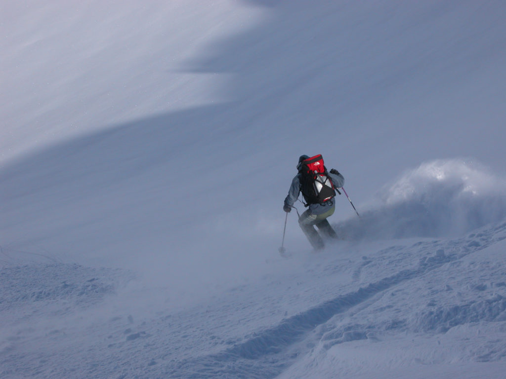
How steep is the slope in the photo below? It is early season, late afternoon, and the slope is in the shade. The 40-degree roll now blends into the foreground and becomes difficult to see. Only the sluffing snow from the previous skier reveals the true steepness of the terrain.
Tip: Caution! Your moderate angled slope may be connected to adjacent, steeper terrain

22°
28°
35°
Angle = 40º
Critical Slope Length > 20m
Skier at the fracture line
Roll over the icons to explore the varying slope angles
Photo: Steve Chambers
Photo: Steve Chambers
Several backcountry accidents and fatalities have occurred when riders on a mellower slope triggered the slope adjacent to or above the group. This happens during periods of higher hazard when a uniform and problematic persistent weak layer—made up of a larger irregular grain (facets or surface hoar)—connects both the lower-angled and the steeper sections of the slope.
In the photo above, the gentle glaciated terrain avalanched and surprised the last three skiers on the slope. The leader underestimated how the weak layer (in this case surface hoar) was contiguous to the gentle skied slope and to the steep, convex rollover to the skiers’ left. While their track didn’t go anywhere near the steep section, the weak layer was remotely triggered, and the longer, steeper adjacent slope released, pulling the lower angled slope—and the skiers—down with it.
A Strategy for the Start Zone
Rollover the image to explore the start zone
To reduce our risk, we need to be able to avoid steep terrain when conditions warrant. We need to be able to accurately assess the slope angle of the steepest part of the start zone. We also need to be able to estimate the slope length (>20 meters downslope) and observe the terrain shape of the critical feature. Pay particular attention to convex rollovers and steep slopes above rock outcrops.
That means we need to stop generalizing, guesstimating, and averaging, and use a few tools to train our watchful eye:
Colin Zacharias is a consultant and educator in the avalanche and mountain guiding industries, and an IFMGA/ACMG mountain guide. He resides on Vancouver Island.