Why GPS Is Making Us Dumb
In the economy of action, effort is a cost and the acquisition of skill is driven by the balance of benefits and costs. Laziness is built deep into our nature.
Daniel Kahneman, “Thinking Fast and Slow”
It takes hard work to become a good wilderness navigator. You need to be competent in both wilderness navigation and risk management, i.e. you need to get to the goods and manage your safety. In this sense, a certified ski guide is an expensive labor-saving device. And while there is a free GPS app already loaded on your phone that may help you accomplish the first task, what about the risk management side of things? There’s no app for that yet…
This brings us to the question, “Are you navigating, or are you just following directions?” Being oriented to the landscape is more than just following the blue dot, it is about being immersed in the environment. When traveling through avalanche terrain, this means not only getting from point A to point B, but also assessing the hazards along the way and evaluating the risk versus reward of those actions. Situational awareness is the glue that holds this process together.
So, what does it mean to be situationally aware? It begins with perceiving the critical elements in the environment, followed by understanding the situation. This requires answering questions like, “Where am I?” “Is there anything around me that will cause harm?” The final step in situational awareness is the ability to foresee consequences, i.e. to project the current actions into the future: “If I keep doing this, what is the potential outcome?”
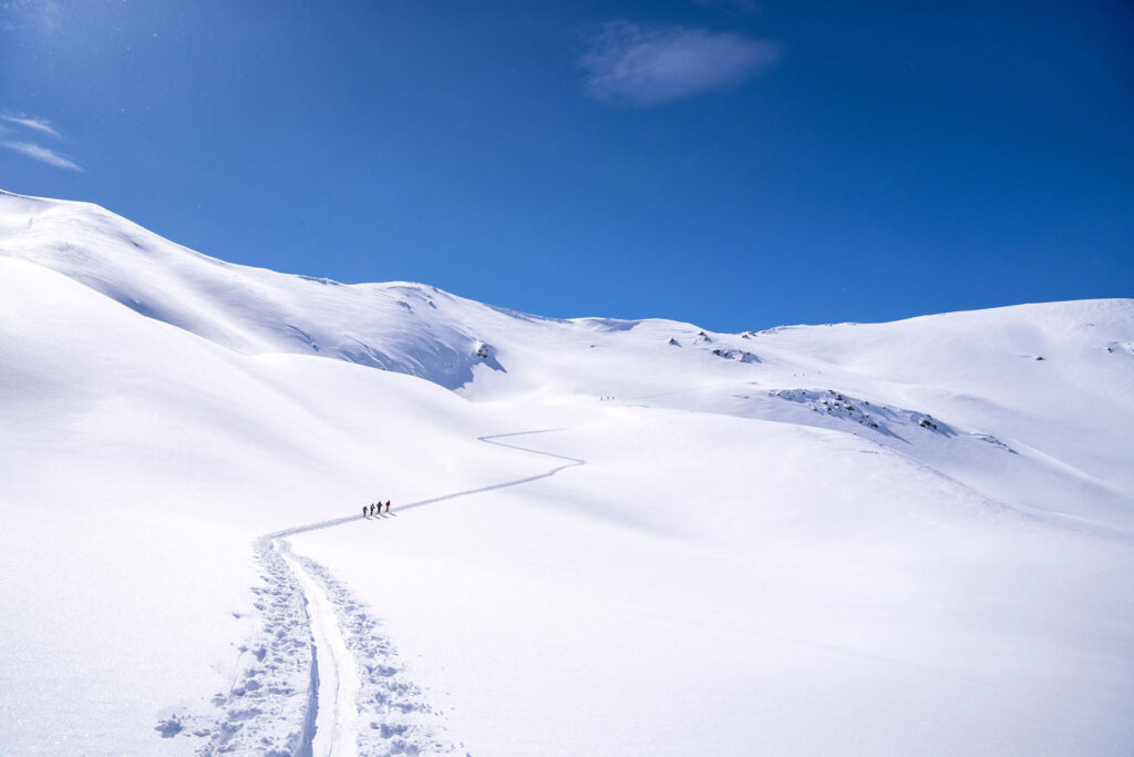
Following a GPS track can actually reduce your situational awareness in avalanche terrain. Your focus can end up on the blue dot rather than on the hazards, terrain, and surrounding landscape, making it easy to lose track of the bigger picture. You need to ask yourself: “What is going on around me?” “How does this fit together?” “The GPS takes me from A to B, and B to C. Can I get from A directly to C?” “Does following the blue dot free up my mental capacity and help me make more focused risk-management decisions, or does it allow my mind to wander and daydream?”
You may be wondering, then, if following an existing uptrack is better than focusing on the blue dot. In terms of building navigational competence, there is no real difference. When it comes to avalanche risk, if the uptrack was made earlier in the day, it represents a decision process relative to the current conditions, whereas the blue dot has no context. Either way, we need to integrate today’s hazard forecast into the route selection. Rather than blindly following the track, fine-tune your situational awareness. Does the track mitigate the risk today? What is above me? What is below me? Does it take me where I want to go? (Read this article for more about the dangers of following tracks.)
In the backcountry, many unforeseen things can (and often do) arise—weather, changing snow conditions, gear malfunctions, etc.—that can force you to change your original plan. When you reach the threshold to initiate a change, travelers with low levels of navigation skills and low levels of avalanche-hazard decision skills likely only have two options: Keep going or turn around. The determining factor is likely their desire. Travelers with higher levels of navigation and decision skills have the ability to generate more options by shifting to plan B, C, or D.
Have you thought about who might be the better navigator, a taxi driver or a bus driver? The bus driver is excellent at following a specific route, and he or she knows every subtlety of it. The taxi driver may have preferred routes, but when there is an accident that blocks it, he or she is able to create a unique solution.
Indeed, scientists conducted a landmark study on London taxi drivers in 2000 to learn how navigation challenges affect the brain. (To get their licenses, London taxi drivers must pass a map test, which takes an average of three to four years of learning the terrain.) The study showed the taxi drivers had a larger posterior hippocampus—which is where spatial data is believed to be stored—than the control group. This suggests the brain can grow—or atrophy—in response to environmental demands. In other words, if you don’t use it, you lose it.
Studies also indicate that having an active and engaged hippocampus increases grey matter, reduces brain atrophy, and delays the potential onset of dementia. We stimulate our hippocampus when we use mapping imagery to plan and follow a route. We improve our knowledge of environmental landmarks. We use knowledge of the terrain that we have gained from pre-planning on a map to interpret the terrain as we move through it. It can be hard work, but, as with any exercise program, we get stronger the more we do it.
On the other hand, when we follow a GPS track, there is no heavy lifting. Our brains get weak. Our navigation skills atrophy. We become more dependent on the blue dot until, eventually, we cannot navigate without the blue dot.
All this is not to say I think we should ditch technology and go back to paper maps. Rather, I think we should use technology to augment traditional navigational practices rather than supplant them. On my apprentice ski guide exam in the late ’80s, our examiner challenged us to memorize the map prior to a trip so that when we were moving through the terrain, we did not need to pull the map out unless the visibility deteriorated. It produced an elegant flow through the terrain as we anticipated and managed features. We can do the same exercise now, only the map in our packs is now a digital route made on mapping software and downloaded on our phones. If the visibility deteriorates, say, in a whiteout on a glacier, we can pull out the phone and follow the blue dot instead of tediously following compass bearings.
If you’re not yet convinced that it’s worth your time and effort to build navigational expertise, here’s another justification for you—getting the goods, which, of course, is why we’re backcountry skiing in the first place. Navigational expertise enables you to maximize the benefit of traveling through untracked snow. Here’s my cost-benefit analysis for getting fresh tracks:
| Level of expertise | Trip planning complexity | Benefit |
|---|---|---|
| No navigation expertise | No pre-trip planning—follow someone else’s trail. | Ride through others’ tracks; get minimal untracked snow. |
| No navigation expertise | No navigation expertise | No navigation expertise |
| Competent computer skills; beginner navigation skills | Create a track using computer software, download to phone, and follow it. | Potential to ride untracked snow, but also potential to run into unmanageable terrain. |
| Minimal navigation expertise | Return to a place you have been before and the track that you created; get there first now that you know the way. | Potential to ride untracked snow, but also lose out on exploring new terrain (and a good night’s sleep). |
| Competent navigation skills | Create a whiteout navigation plan using a paper map and online resources. Carry the paper map, compass, whiteout plan, and GPS. | Ride untracked snow and explore new terrain. |
| Expert navigation skills | Memorize the terrain by studying it on a paper map and online resources. Carry the map, compass, whiteout plan, and GPS as backups. | Ride untracked snow and explore new terrain. |
To summarize, backcountry skiing presents an inherent dilemma: You want to safely ski untracked powder, but you do not know how to get there. If you simply follow tracks to a place that typically has powder, you will get to ride whatever is left. However, if you go back to that area after the next storm and follow the GPS track you made when you rode the leftovers, all you need to do is get up early, break trail, and get there first. If you build expertise with navigation, you develop a better solution. You learn how to analyze the terrain. You find a place that is less popular and will have untracked snow. You break a trail into the area and tell no one about it. You have created your secret stash.
When done well, terrain interpretation is a subtle and nuanced skill. Start by studying and memorizing the map/terrain. Then navigate using your memory of how the terrain comes together. Ask yourself, “If we continue up this ridge, how does it connect?” “What happens if we drop down into this ravine?” This all, of course, leads to getting to the goods—and staying alive to ride them again and again.
Iain Stewart-Patterson, PhD, has been guiding snow, rock, and ice adventures for over 40 years. He is an IFMGA mountain guide and earned a PhD for his studies in decision-making in avalanche terrain. He is also a consultant for the Canadian Avalanche Association, Association of Canadian Mountain Guides, Avalanche Canada, and others; an avalanche educator with the Canadian Avalanche Association Industry Training Program; an ITP snowmobile course leader; and a professor emeritus at Thompson Rivers University in Kamloops, B.C.